
Cartes géographiques
Date de sortie
- 5869 tous
- publiés
- 139 moins de 3 mois
- 34 moins d'un mois
- 13 moins d'une semaine
- 65 à paraître
- 6 dans la semaine qui vient
- 18 dans le mois qui vient
Disponibilité
Prix
- 70 inférieur à 5 €
- 955 de 5 à 10 €
- 2603 de 10 à 20 €
- 2152 de 20 à 40 €
- 69 supérieur à 40 €
-

-

-

-
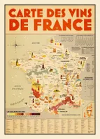 La carte des vins de France (pliée) - un poster géant pour voir le vin en grandPersan, MathieuHachette Pratique9,95
 -
-

-
-
-
 Top 100, 156, Top100156 Le-Puy-En-Velay / Privas / Mende 1/100.0XxxIGN – Institut Géographique National8,40
 -

-
 Top 100, 170, Top100170 Montpellier / Nimes / Beziers 1/100.000XxxIGN – Institut Géographique National8,40
 -
 Top 100, 153, Top100153 Perigueux / Bergerac 1/100.000XxxIGN – Institut Géographique National8,40
 -
 Top 100, 148, Top100148 Clermont-Ferrand / Salers 1/100.000XxxIGN – Institut Géographique National8,40
 -
 Top 25 : une carte, un site, 2138OT, 2138Ot Cahors.Saint-Cirq-Lapopie.Vallees Du Lot EtXxxIGN – Institut Géographique National13,90
 -
![Série bleue [nouveau format], 2030SB, 2030Sb Ambazac.Nantiat](//cdn.leslibraires.fr/EC77ah3ieY_Jbfch9enMr-8o_JWzOIz9eJNvR8zVaSQ/s:200:200/NjE1MTAwNw.webp) Série bleue [nouveau format], 2030SB, 2030Sb Ambazac.NantiatXxxIGN – Institut Géographique National13,90
Série bleue [nouveau format], 2030SB, 2030Sb Ambazac.NantiatXxxIGN – Institut Géographique National13,90 -
![Série bleue [nouveau format], 2238SB, 2238Sb Figeac.Cajarc](//cdn.leslibraires.fr/mfd_fAS_NroKjyf36MyFrWXQrVXMpgzv5g4OZNeUdG8/s:200:200/NjE1MTAyNw.webp) Série bleue [nouveau format], 2238SB, 2238Sb Figeac.CajarcXxxIGN – Institut Géographique National13,90
Série bleue [nouveau format], 2238SB, 2238Sb Figeac.CajarcXxxIGN – Institut Géographique National13,90 -
 Top 25 : une carte, un site, 2538OT, 2538Ot Sainte-Eulalie-D'Olt.Haute Vallée Du Lot.MoXxxIGN – Institut Géographique National13,90
 -
![Série bleue [nouveau format], 2132SB, 2132Sb Châteauneuf-La-Forêt.Chamberet](//cdn.leslibraires.fr/l6DhMuw_XgqilBGNDvTi2koEQszeFIAmL1s4q-AHrtI/s:200:200/NTc3MzAyNw.webp) Série bleue [nouveau format], 2132SB, 2132Sb Châteauneuf-La-Forêt.ChamberetXxxIGN – Institut Géographique National13,90
Série bleue [nouveau format], 2132SB, 2132Sb Châteauneuf-La-Forêt.ChamberetXxxIGN – Institut Géographique National13,90 -
![Série bleue [nouveau format], 2232SB, 2232Sb Bugeat.Peyrelevade](//cdn.leslibraires.fr/aGaolKpRuU__3mBFtCJGUUzTh4VpioFBFvtelUcJWwQ/s:200:200/NTQ1NjQ0OQ.webp) Série bleue [nouveau format], 2232SB, 2232Sb Bugeat.PeyrelevadeXxxIGN – Institut Géographique National13,90
Série bleue [nouveau format], 2232SB, 2232Sb Bugeat.PeyrelevadeXxxIGN – Institut Géographique National13,90 -
![Série bleue [nouveau format], 1929SB, 1929Sb Bellac.Adriers](//cdn.leslibraires.fr/qiDnPS5cfj93OPd_DaKlWMXBz1-ZCW7Js4TsdI8WnjE/s:200:200/NTQ1NjQ0Mg.webp) Série bleue [nouveau format], 1929SB, 1929Sb Bellac.Adriers1929SbIGN – Institut Géographique National13,90
Série bleue [nouveau format], 1929SB, 1929Sb Bellac.Adriers1929SbIGN – Institut Géographique National13,90 -
![[France] départementale, routière et touristique, D15-19, D721312 Cantal.Correze](//cdn.leslibraires.fr/Gc6fsL1UbyRvnmvZWYt9U-vMG7M30ipjJqIM6XtGYvw/s:200:200/MTE4MTM3MDQ.webp) [France] départementale, routière et touristique, D15-19, D721312 Cantal.CorrezeXxxIGN – Institut Géographique National5,90
[France] départementale, routière et touristique, D15-19, D721312 Cantal.CorrezeXxxIGN – Institut Géographique National5,90 -
-
![Série bleue [nouveau format], 2028SB, 2028Sb St-Sulpice-Les-Feuilles.Lussac-Les-Églises](//cdn.leslibraires.fr/t2awTntta1QE8mfVt9Il6Aar71YUWitVoR7H4qrlDCI/s:200:200/NTM2MTExMw.webp) Série bleue [nouveau format], 2028SB, 2028Sb St-Sulpice-Les-Feuilles.Lussac-Les-ÉglisesXxxIGN – Institut Géographique National13,90
Série bleue [nouveau format], 2028SB, 2028Sb St-Sulpice-Les-Feuilles.Lussac-Les-ÉglisesXxxIGN – Institut Géographique National13,90


![Série bleue [nouveau format], 2030SB, 2030Sb Ambazac.Nantiat](http://cdn.leslibraires.fr/EC77ah3ieY_Jbfch9enMr-8o_JWzOIz9eJNvR8zVaSQ/s:200:200/NjE1MTAwNw.webp)
![Série bleue [nouveau format], 2238SB, 2238Sb Figeac.Cajarc](http://cdn.leslibraires.fr/mfd_fAS_NroKjyf36MyFrWXQrVXMpgzv5g4OZNeUdG8/s:200:200/NjE1MTAyNw.webp)

![Série bleue [nouveau format], 2132SB, 2132Sb Châteauneuf-La-Forêt.Chamberet](http://cdn.leslibraires.fr/l6DhMuw_XgqilBGNDvTi2koEQszeFIAmL1s4q-AHrtI/s:200:200/NTc3MzAyNw.webp)
![Série bleue [nouveau format], 2232SB, 2232Sb Bugeat.Peyrelevade](http://cdn.leslibraires.fr/aGaolKpRuU__3mBFtCJGUUzTh4VpioFBFvtelUcJWwQ/s:200:200/NTQ1NjQ0OQ.webp)
![Série bleue [nouveau format], 1929SB, 1929Sb Bellac.Adriers](http://cdn.leslibraires.fr/qiDnPS5cfj93OPd_DaKlWMXBz1-ZCW7Js4TsdI8WnjE/s:200:200/NTQ1NjQ0Mg.webp)
![[France] départementale, routière et touristique, D15-19, D721312 Cantal.Correze](http://cdn.leslibraires.fr/Gc6fsL1UbyRvnmvZWYt9U-vMG7M30ipjJqIM6XtGYvw/s:200:200/MTE4MTM3MDQ.webp)

![Série bleue [nouveau format], 2028SB, 2028Sb St-Sulpice-Les-Feuilles.Lussac-Les-Églises](http://cdn.leslibraires.fr/t2awTntta1QE8mfVt9Il6Aar71YUWitVoR7H4qrlDCI/s:200:200/NTM2MTExMw.webp)